LOCATION
Ontario, Canada
SIZE
61,575 ha
STAGE
Grassroots
DEPOSIT TYPE(S)
Orogenic Au, VMS, Magmatic Ni-Cu, Li-Cs-Ta Pegmatite
The Flora Project covers 61,575 hectares in northwestern Ontario. It covers a significant strike length of metavolcanic and metasedimentary rocks along the regional scale Wabigoon Fault. It has potential for hosting several deposit types, with the Kenbridge magmatic Ni-Cu, the Cameron orogenic Au deposit and peraluminous Ghost Lake batholith located in the vicinity of the Project. Limited systematic work has been carried out within the project area, and the Flora project represents an opportunity for discovery in a favorable jurisdiction with excellent infrastructure. On June 25, 2025, the Flora Project was optioned to Centerra Gold Inc. under an earn-in agreement, whereby Centerra may acquire up to a 70% interest in the Flora Project.
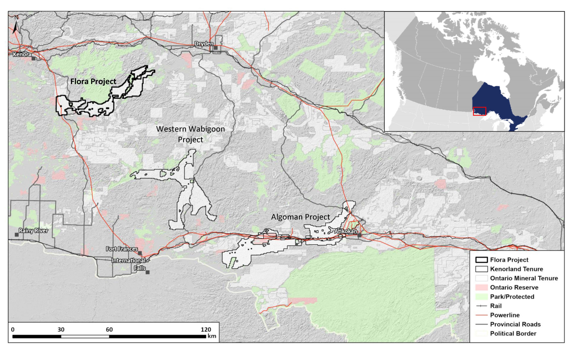
Location and Access
The Flora Project is located within the Kenora Mining District of Western Ontario. It lies adjacent to the community Sioux Narrows and 65km to the southwest of Dryden. The property is accessible through an extensive forestry road network of roads which connect to provincial highways. A high-power transmission line crosses the eastern portion of the Project.
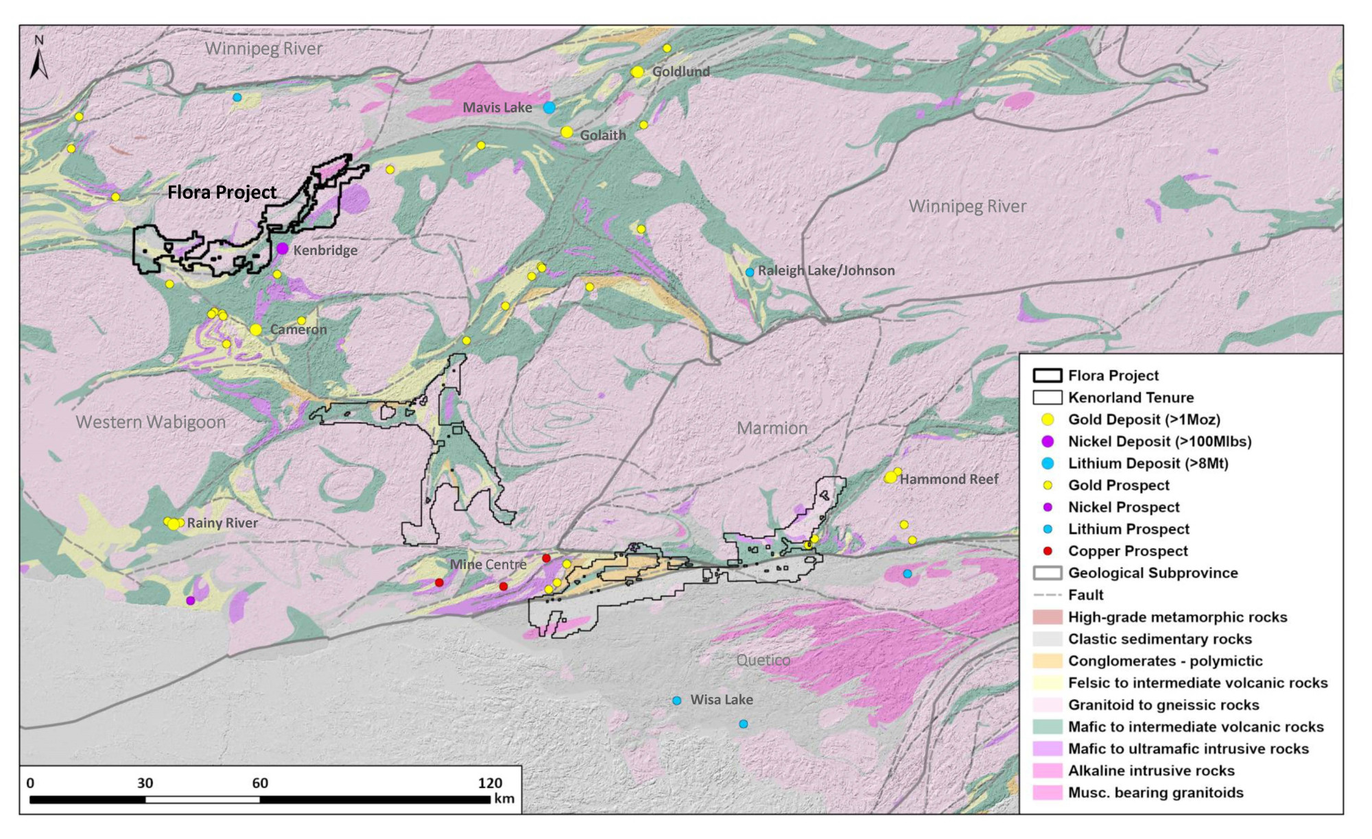
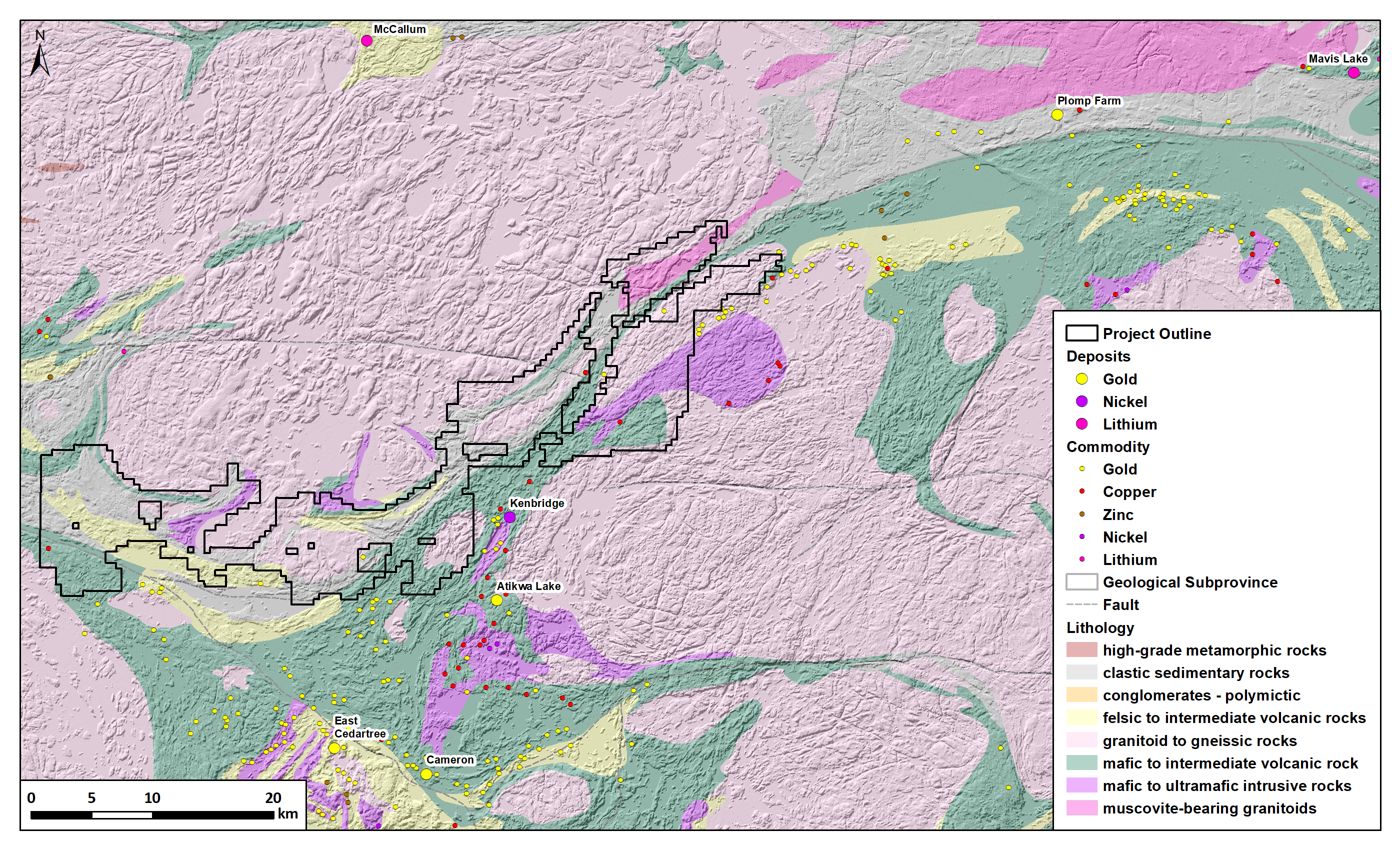
Geology and Mineralisation
The property is situated at the western end of the Late Archean Western Wabigoon Subprovince of the Archean Superior Province. Within the Project area, a variety of geological environments with potential of hosting several deposit types including Ni-Cu sulphide, VMS-style mineralisation and shear zone hosted gold deposits. The Warclub assemblage covers the northwestern portion of the Project, a belt of predominantly metasedimentary and felsic metavolcanic rocks locally hosting chert-magnetite iron formation. The major Wabigoon Fault juxtaposes these rocks against the Populus Lake Group mafic volcanics and associated ultramafic intrusions to the south. Mineralisation styles within the region include magmatic Ni-Cu sulphide deposits such as the Kenbridge 3km east of the property, orogenic Au deposits such as the Cameron deposit 15km to the south, and local VMS occurrences. Evolved muscovite bearing granites are also mapped to the northeast of the property, approximately 30km from the peraluminous Ghost Lake batholith, which is spatially associated with several Li-Cs-Ta pegmatite occurrences.
Exploration History
The area covered by the Flora Project is a region of relatively low exploration maturity. Only 30 drill holes are located within the Project area which predominantly targeted geophysical anomalies with magmatic Ni-Cu potential. Little regional systematic geochemical exploration or detailed geophysical surveys have been conducted on the property.
Summary of exploration activities conducted by Kenorland Minerals
Since staking of the Project in April 2023, Kenorland has completed the compilation and digitization of historical exploration data within the Project area. A LIDAR survey was flown by Kenorland in the summer of 2023 to aid in surficial geological interpretation and planning of systematic geochemical surveys.
Geochemical surveys completed in 2024 and 2025 have outlined the F1 target as a large-scale, high-tenor gold-in-till anomaly extending over 7 kilometres within a sheared diorite, coincident with a coherent 7 kilometre trend of strong gold grain results from HMC till sampling. Mapping and prospecting within the F1 area identified high-grade gold mineralisation, with rock samples returning up to 31.70 g/t Au in the central portion of the target area and up to 17.40 g/t Au approximately 3 kilometres to the northeast. No historical drilling has been completed in the F1 area. The Company completed extensive follow-up work during the 2025 exploration program, including infill soil samples on a 100 m x 200 m grid across both the F1 and F2 target areas, along with mapping and prospecting. In addition, HMC till samples were collected at 250 m x 500 m spacing for gold grain analysis, and a heliborne magnetic, VLF-EM, and radiometric survey was flown over the F1 target to refine structural and lithological interpretation and support ongoing target development.
At the Flora Project, 2026 work will focus on additional surface exploration, including mapping and prospecting to help refine targets intended to position Flora for a future drill program.